Back Велика северна експедиция Bulgarian Сийлахь-Йоккха Къилбаседа экспедици CE Velká severní expedice Czech 2. Kamtjatka-ekspedition Danish Zweite Kamtschatkaexpedition German Segunda expedición a Kamchatka Spanish Deuxième expédition du Kamtchatka French Seconda spedizione in Kamčatka Italian Tweede Kamtsjatka-expeditie Dutch Великая Северная экспедиция Russian
This article needs additional citations for verification. (November 2020) |


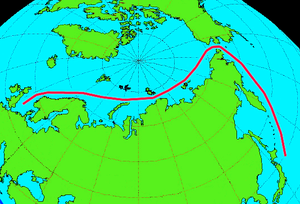
The Great Northern Expedition (Russian: Великая Северная экспедиция) or Second Kamchatka Expedition (Russian: Вторая Камчатская экспедиция) was one of the largest exploration enterprises in history, mapping most of the Arctic coast of Siberia and some parts of the North American coastline, greatly reducing "white areas" on maps. It was conceived by Russian Emperor Peter the Great, but implemented by Russian Empresses Anna and Elizabeth. The main organiser and leader of the expedition was Vitus Bering, who earlier had been commissioned by Peter I to lead the First Kamchatka Expedition (1725 to 1731). The Second Kamchatka Expedition lasted roughly from 1733 to 1743 and later was called the Great Northern Expedition due to the immense scale of its achievements.
The goal was to find and map the eastern reaches of Siberia, and hopefully the western shores of North America. Peter I had a vision for the 18th-century Russian Navy to map a Northern Sea Route from Europe to the Pacific. This far-reaching endeavour was sponsored by the Admiralty College in Saint Petersburg.
With over 3,000 people directly and indirectly involved, the Second Kamchatka Expedition was one of the largest such projects in history. Its cost, completely financed by the Russian state, reached an estimated 1.5 million rubles, an enormous sum for the time; roughly one sixth of the income of the Russian state in 1724.[1]
The achievements of the expedition included the European discovery of Alaska, the Aleutian Islands, the Commander Islands, Bering Island, as well as a detailed cartographic assessment of the northern and north-eastern coast of Russia and the Kuril Islands. It definitively refuted the legend of a land mass in the north Pacific, and did ethnographic, historic, and scientific research into Siberia and Kamchatka. When the expedition failed to round the north-east tip of Asia, the dream of an economically viable Northeast passage, sought since the 16th century, was at an end.
- ^ Hintzsche / Nickol, Die Große Nordische Expedition, p. 200.
© MMXXIII Rich X Search. We shall prevail. All rights reserved. Rich X Search